
Remote sensing reveals the rapid spread of gold mines in the Amazon
Remote sensing reveals the rapid spread of gold mines in the Amazon
Researchers use cutting-edge technologies to track rapidly expanding gold mining operations in the Peruvian Amazon.
Original Paper:
Asner GP, Llactayo W, Tupayachi R, Luna ER. (2013) "Elevated rates of gold mining in the Amazon revealed through high-resolution monitoring." Proceedings of the National Academy of Sciences. 110(46): 18454-18459.
DOI: http://dx.doi.org/10.1073/pnas.1318271110.
Ashe K. (2012) "Elevated Mercury Concentrations in Humans of Madre de Dios, Peru." PLoS ONE. 7(3): e33305.
DOI: http://dx.doi.org/10.1371/journal.pone.0033305.
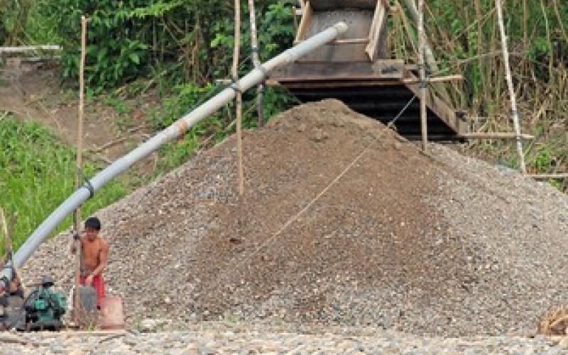
A gold rush of sorts has emerged in Madre de Dios, a densely forested region in the southeast corner of Peru. The global price of gold has increased dramatically since the 2008 financial crisis. Many gold miners are working at unpermitted mines with little or no government oversight, leaving communities at risk of mercury exposure and forests at risk of overexploitation. Advances in remote sensing, which incorporate both satellite imagery and information gathered by sensors on airplanes, allow scientists to ask big questions about previously difficult-to-access places, such as the Amazon.
A team of researchers from Stanford University used satellites, airplane-based sensors, and first-hand field observations to track the spread of gold mines in Madre de Dios. The researchers looked at satellite images collected annually between 1999 and 2012.
The satellite images revealed less than 10,000 hectares (approximately 40 square miles) of mines in 1999. By 2012, the satellites revealed over 50,000 hectares (approximately 190 square miles) of mines.
The researchers used the Carnegie Airborne Observatory, a small passenger plane outfitted with sophisticated sensors, to fly over Madre de Dios and take a second look at gold mines through a different lens. The team spent two months on the ground verifying the satellite images and data from the airborne sensors. Taken together, the team confirmed 94% of the mines the satellites had revealed.
The spread of gold mines in Madre de Dios raises concerns of mercury poisoning and environmental degradation, as vast swaths of forest are clear-cut to make way for mines. After extracting ore, miners mechanically combine equal parts of mercury and gold ore to make what's called an amalgam. Workers then heat the amalgam to separate out the gold, creating hazardous mercury vapors in the process. Workers at informal mines are at risk of inhaling mercury vapors due to the lack of adequate protective equipment. Mercury poisoning is a serious problem with serious health threats, and the rapid spread of unpermitted gold mines may put more people at risk.
The combination of remote sensing from satellites and airplanes with on-the-ground observations sheds light on the growing issue of unpermitted gold mines. Understanding the extent of mining operations, researchers can now turn to getting a better sense mining's effects on ecosystems and communities in Madre de Dios.
You might like these articles that share the same topics
The Malaysian state of Sarawak started its implementation of a gigantic hydropower project with the goal to leapfrog into modernity. This causes a range of unfavorable consequences that should be carefully assessed by other countries in the region that plan to install similar projects.
Regions containing much of the biological diversity on Earth should be conserved for reasons beyond the plant and animal species within them.

Scientists explore how entrepreneurs and decision makers can make or break how a national park benefits a community

Many conservationists and land planners look to property tax policy to encourage private landowners to keep their land undeveloped. While property tax can hold back the conversion of rural land to some extent, its impact is limited.